ATLANTA — Saturday marks the official start of the 2024 Atlantic hurricane season and it could be an active one.
Hurricane season runs from the beginning of June through the end of November and typically peaks around Sept. 10.
Severe Weather Team 2 always encourages you to be weather aware and that will be important over the next six months.
[DOWNLOAD: Free WSB-TV News app for alerts as news breaks]
There were 20 named storms during the 2023 Atlantic hurricane season, including seven hurricanes. Three of those made landfall in the U.S.
But it’s likely the number of hurricanes will increase in 2024.
Severe Weather Team 2 Chief Meteorologist Brad Nitz says there are a couple of ingredients that are influencing the forecast for this hurricane season.
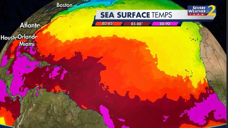
First off, there have been historically warm waters in the main developing region of the tropical Atlantic. The water temperature is more like what you’d expect in early August than this time of year.
In addition to that, the El Niño that has been around for the last several months in the tropical Pacific, that’s weakening.
Nitz says the warm waters are starting to cool as we transition to a La Niña.
La Niña weather pattern means lighter winds across the tropical Atlantic.
“That lower wind shear means increased hurricane activity, you combine that with the historically warm waters, I expect this is going to be a blockbuster hurricane season,” Nitz says.
TRENDING STORIES:
- LIVE UPDATES: City-wide water service disruption to begin at 5 p.m.
- Skeletal remains found in Tennessee identified as 20-year-old last seen leaving Gwinnett jail
- People need to prepare to not have water for unspecified amount of time, Watershed says
The National Oceanic and Atmospheric Administration said it predicts there will be between 17 and 25 named storms with eight to 13 becoming hurricanes. NOAA predicts between four to seven storms could become major hurricanes.
Hurricane season typically peaks around Sept. 10.
Shortly before that, in mid-August, the National Hurricane Center will test a new way to help people better understand the potential threat they face.
It involves changes to graphics showing the “cone of uncertainty.”
“We’re going to be, placing, the watches in the inland watches and warnings on that cone so we can collaborate these with the local National Weather Service offices,” said Daniel Brown with the NHC.
The usual cone shows the probable path of the center of a storm over five days. Severe Weather Team 2 has always focused on our inland impacts. Now the NHC’s new experimental cone forecast will also highlight inland areas under threat.
“I think one of the hardest messages to get across is that every storm is different. Don’t base your preparedness decisions on a previous hurricane experience,” Brown said.
It’s important for Georgians to be extra weather aware. Hurricane Irma in 2017, Hurricane Matthew in 2016 and Tropical Storm Cindy in 2005 are all reminders that Georgia can experience devastation from tropical systems.
On Sept. 10, 2017, Hurricane Irma slammed into southwest Florida. A day later as a tropical storm, it caused two deaths in north Georgia and knocked out power to more than 1.5 million people across the state.
[SIGN UP: WSB-TV Daily Headlines Newsletter]
In Oct. 2016, Hurricane Matthew had major impacts across South Georgia. The storm killed three people and caused massive flooding and power outages.
In July 2005, an EF-2 tornado formed during Tropical Storm Cindy and slammed into the Atlanta Motor Speedway in Henry County.
“All this damage, it’s just unreal.”
The same storm system flooded streets and neighborhoods all over metro Atlanta.
“I’m still not sure I was prepared for what I saw until I actually drove up and saw it.”
“Just unbelievable that nature could do something like this.”
IN OTHER NEWS:

©2024 Cox Media Group