
ATLANTA — Metro Atlanta got a lot of rain and a few strong storms early Sunday morning as a powerful weather system makes its way through the state.
Severe Weather Team 2 has been tracking the system since Saturday. The line of storms could be strong to severe. A brief, spin-up tornado can’t be ruled out for eastern areas during the day on Sunday.
Severe Weather Team 2 is tracking the heavy rain, storms LIVE on Channel 2 Action News Sunday AM. Download the WSB weather app for alerts.
LIVE UPDATES:
7:45 a.m.
Most of the heavy rain and storms have moved far south of the Atlanta area. Severe Weather Team 2 Meteorologist Brian Monahan said many areas picked up over an inch of rain. More rain is expected throughout the day on Sunday with the weather turning much, much colder beginning late Sunday night into Monday morning.
Parts of the area have picked up another 1-2" of rain over the last 12 hours... with more falling through the morning as a strong cold front moves through! @wsbtv pic.twitter.com/Xr0PjEbyyy
— Brian Monahan, WSB (@BMonahanWSB) January 2, 2022
5:34 a.m.
Tornado watch canceled, but risk for isolated strong/severe storm is possible for east areas Sunday morning.
Tornado watch canceled, but risk for isolated strong/severe storm at leading edge of strong line moving through north Georgia continues. Tracking with @EboniDeonWSB all morning long on Channel 2. @wsbtv pic.twitter.com/T5e2uq9YA5
— Brian Monahan, WSB (@BMonahanWSB) January 2, 2022
5:09 a.m.
The tornado watch from earlier in the morning has been lifted but the risk of strong storms remains.
Strong storms moving into much Fulton County now... headed toward the Chattahoochee. While tornado watch has dropped, risk remains for 40-60 mph wind gusts and heavy rain.
— Brian Monahan, WSB (@BMonahanWSB) January 2, 2022
Tracking with @EboniDeonWSB now on Channel 2. @wsbtv pic.twitter.com/M3DHcfa3Af
4:49 a.m.
The heaviest rain is now starting to push through metro Atlanta.
Good Sunday morning! Rain and storms moving through this morning and a Tornado Watch continues for parts of west Georgia until 6AM. Severe Weather Team 2 is tracking it for you live starting at 5AM. pic.twitter.com/L1aXUOo7q1
— Eboni Deon, WSB (@EboniDeonWSB) January 2, 2022
4:15 a.m.
So far, just wind damage reports to our west from this line. We’ll be monitoring leading edge though for risk of brief spin-up tornado as it moves through. @wsbtv pic.twitter.com/O4kqlysIrG
— Brian Monahan, WSB (@BMonahanWSB) January 2, 2022
4:12 a.m.
Heavy rain and risk for isolated severe storms moving into much of metro Atlanta over the next hour or two.
— Brian Monahan, WSB (@BMonahanWSB) January 2, 2022
Tornado watch continues over northwest Georgia. @wsbtv pic.twitter.com/adnd9AP9FW
3:56 a.m.
Temperatures remain in the 60s and 70s across north Georgia as the line approaches.
4 am temps are just so ridiculous. BTW, our high yesterday was a record 78 degrees.
Posted by Glenn Burns on Sunday, January 2, 2022
3:23 a.m.
Heavy rains and 25-35 MPH winds moving into the metro Atlanta area.
Here's an estimate on when that heavy rain and the 25-35 mph wind gusts will likely reach you.
Posted by Glenn Burns on Sunday, January 2, 2022
2:59 a.m.
Tornado watch will not move further east.
TORNADO WATCH FOR OUR NORTHERN COUNTIES HAS EXPIRED. Sleep well my friends in those counties. TORNADO WATCH for the rest of us continues until 6 am. It will not be extended any further east.
Posted by Glenn Burns on Saturday, January 1, 2022
2:45 a.m.
Burns says the lightning count is lowering, which is a good sign.
At 2:45 am my lightning counter continues to tick down. A GREAT sign. Storm intensity shows a weakening trend as well....
Posted by Glenn Burns on Saturday, January 1, 2022
2:30 a.m.
The tornado watch has been canceled for a few counties.
At 2:30 am non-severe T-Storms are moving NE at 50 mph across our northwest counties. No warnings. Main threat is...
Posted by Glenn Burns on Saturday, January 1, 2022
1:30 a.m.
Burns says some areas could see localized flooding.
WATCHING SOME OF THE RAINFALL AMOUNTS. COULD SEE SOME LOCALIZED FLOODING ISSUES. With saturated soil it won't take much wind to down trees.
Posted by Glenn Burns on Saturday, January 1, 2022
12:45 a.m.
NO WARNINGS ALONG THE SQUALL LINE OVER THE PAST HOUR. MY CONCERN WOULD BE BRIEF SPIN UP TORNADOES ALONG THE LEADING EDGE OF THAT LINE. THE LIGHTNING IS JUST RIDICULOUS.
Posted by Glenn Burns on Saturday, January 1, 2022
11:07 p.m.
A tornado watch has been issued for Bartow, Carroll, Cherokee, Cobb, Douglas, Floyd, Haralson, Heard, Paulding, Polk and Troup counties until 6 a.m.
9:55 p.m.
A tornado warning has been issued for Walker and Dade counties until 10 p.m.
7:52 p.m.
A tornado watch has been issued for Catoosa, Chattooga, Dade, Fannin, Gilmer, Gordon, Murray, Pickens, Towns, Union, Walker and Whitfield counties until 3 a.m.
https://t.co/KebYF1J7my pic.twitter.com/h8MDKdMeBY
— Brad Nitz (@BradNitzWSB) January 2, 2022
Here is what to know as the system moves through:
- Level 3 out of 5 risk for severe weather in northwest Georgia counties.
- Metro Atlanta area is facing a Level 2 out of 5 risk.
- Main risks are heavy rain with potential flooding, damaging wind gusts and possibility of spin up tornadoes.
Severe Weather Team 2 Meteorologist Eboni Deon said the front is likely to move into the northwest part of the state as early as 9 p.m. with the stronger weather making its way into the state beginning around midnight.
The timeline for metro Atlanta appears to be between 4 a.m. and 7 a.m. Sunday.
TRENDING STORIES:
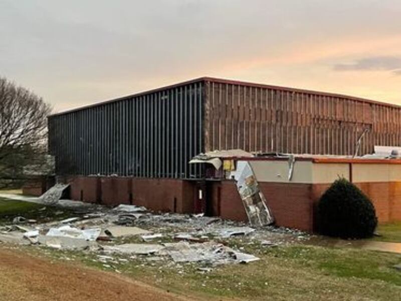
- Tornadoes leave damage behind across metro Atlanta
- Businesses, middle school damaged by likely tornado in Newton County
- PHOTOS: Tornadoes move through parts of metro Atlanta
[SIGN UP: WSB-TV Daily Headlines Newsletter]
Severe Weather Team 2 Meteorologist Brian Monahan said showers will linger through most of the day on Sunday as the rest of the front crosses through the state.
Once it passes, he said temperatures will drop quickly as cold air comes rushing in.
Showers will linger most of the day Sunday... then as last bit of upper level energy comes across and cold air comes in... chance for the northern half of the area to see a period of some rain/snow mix... especially into the mountains Monday morning. @wsbtv
— Brian Monahan, WSB (@BMonahanWSB) January 1, 2022
Monahan and Severe Weather Team 2 Chief Meteorologist Glenn Burns say the lingering showers, combined with the cold air, could create areas of a rain and snow mix in the northern mountains of the state early Monday morning.
©2021 Cox Media Group


